
GPS devices serve three core functions: precise positioning, navigation, and timing. Every application you rely on, from turn-by-turn driving directions to synchronized financial transactions, traces back to one of these three roles. Here is what GPS devices actually do:
- Positioning: A GPS device calculates your exact location on Earth, expressed as latitude, longitude, and altitude, using signals from satellites orbiting roughly 12,550 miles above the surface.
- Navigation: Once your position is known, GPS guides you from point A to point B, whether you are driving a highway, hiking a ridgeline, or piloting a cargo ship.
- Timing: GPS satellites carry atomic clocks accurate to billionths of a second. That precision keeps cell towers, power grids, and banking networks synchronized worldwide.
These three roles, as defined by GPS.gov, underpin applications that billions of people use daily, from smartphone maps to emergency response systems. The technology works in civilian and military contexts alike, which is why understanding it matters well beyond knowing how to get directions.
What is GPS and how does it fit within global satellite navigation?
GPS, the Global Positioning System, is a satellite-based navigation system owned and operated by the U.S. Space Force. It was originally built for military use, but today it serves as open, free infrastructure for the entire world. The system is organized into three segments: the space segment (the satellites), the control segment (ground stations that monitor and correct the satellites), and the user segment (every receiver, from your phone to a precision farming tractor).
GPS is one of four fully operational Global Navigation Satellite Systems, known collectively as GNSS. The FAA describes the full constellation this way:
The U.S. GPS constellation currently operates with a full complement of active satellites. Modernization efforts, including the GPS III satellite series, have added new civil signals, stronger anti-jamming capability, and improved accuracy over earlier generations. GPS III satellites also carry a Search and Rescue payload, connecting the system directly to international distress beacon monitoring.
Key facts about the GPS system:
- The basic GPS service provides approximately 7.0 meters of accuracy, 95% of the time, anywhere on or near Earth's surface.
- Augmentation systems like the FAA's Wide Area Augmentation System (WAAS) push accuracy into the sub-meter range for aviation and precision applications.
- GPS signals are free to receive; no subscription or registration is required for basic positioning.
- The control segment includes a master control station at Schriever Space Force Base in Colorado, with dedicated ground antennas and monitoring stations distributed globally.
How GPS devices work: signals, satellites, and trilateration
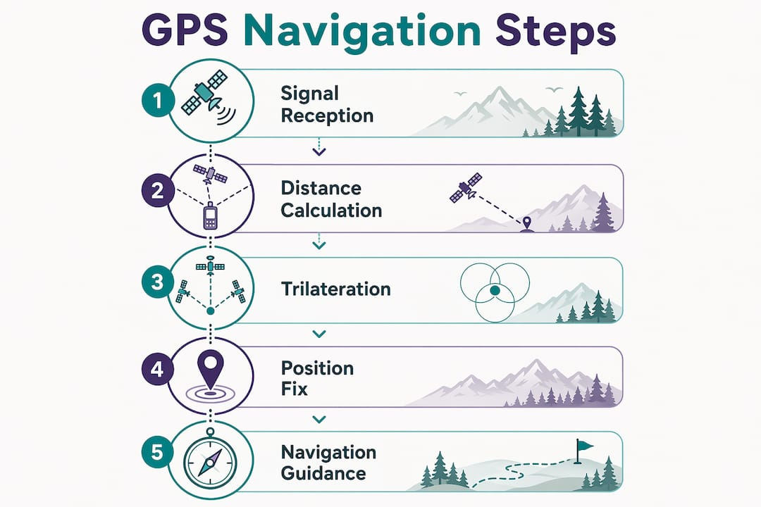
Every GPS receiver, whether it is a dedicated hiking unit or the chip inside your phone, follows the same fundamental process. GPS satellites continuously broadcast coded radio signals, each stamped with the precise time of transmission from an onboard atomic clock. Your receiver picks up those signals and measures how long each one took to arrive.

That travel time, multiplied by the speed of light, gives the distance from your device to each satellite. With distances from at least four satellites, the receiver can calculate your latitude, longitude, altitude, and the exact time, all at once. This process is called trilateration, and it requires four satellites rather than three because the receiver's internal clock is not atomic-grade and needs that fourth measurement to correct its own timing error.
One detail that surprises many people: GPS is a receive-only system. Your device never transmits anything back to the satellites. It simply listens, calculates, and displays your position. That means an unlimited number of users can use GPS simultaneously without congesting the system.
Here is how the process breaks down step by step:
- Satellites broadcast signals encoded with their precise location and transmission time.
- Your receiver captures signals from at least four satellites.
- The receiver calculates the distance to each satellite using signal travel time.
- Trilateration combines those distances to pinpoint your 3D position and correct for clock error.
- The receiver displays or transmits your coordinates to an app, map, or tracking platform.
Accuracy can degrade in certain conditions. Dense tree cover, urban canyons with tall buildings, and deep valleys all block or reflect signals, introducing errors. The ionosphere and troposphere slow signals slightly, which receivers must account for mathematically. Multi-constellation GNSS devices that pull signals from GPS, GLONASS, Galileo, and BeiDou simultaneously see far more satellites at any moment, which reduces the chance of a positioning gap in challenging terrain.
Pro Tip: When you are hiking in a dense forest or a narrow canyon, a receiver that supports multiple GNSS constellations will maintain a fix far more reliably than a GPS-only unit. Look for devices that list GLONASS or Galileo compatibility on the spec sheet.
Where GPS technology gets applied across industries and daily life
The applications of GPS devices span nearly every sector of modern life. Positioning and timing show up in places most people never think to look.

Navigation and transportation
Turn-by-turn navigation for cars, trucks, and motorcycles is the most visible use. Aviation depends on GPS for instrument approaches, en route navigation, and the FAA's NextGen Air Transportation System, which increases airspace capacity while reducing fuel burn. Maritime vessels use GPS for harbor approaches, offshore routing, and collision avoidance. For outdoor adventurers, GPS for outdoor activities means real-time trail tracking, waypoint marking, and the ability to retrace a route in zero-visibility conditions.
Tracking people, pets, and assets
GPS locator devices let caregivers monitor individuals who may wander, track fleet vehicles in real time, and recover stolen equipment. Many GPS tracking devices require an active cellular or satellite data connection to transmit location updates; without that connection, the device may log a track internally but cannot push live alerts. That distinction matters when choosing a device for safety-critical applications.
Precision agriculture, construction, and surveying
GPS-guided tractors plant and harvest crops in rows accurate to inches, reducing overlap and cutting input costs. Construction crews use GPS machine control to grade land and place foundations without traditional survey stakes. Surveyors rely on differential GPS and real-time kinematic (RTK) positioning to achieve centimeter-level accuracy for legal boundary work.
Timing for critical infrastructure
Cell towers use GPS timing to synchronize handoffs between towers. Financial exchanges timestamp every trade with GPS-derived time to meet regulatory requirements. Power grid operators use GPS timing to detect faults and coordinate load balancing across transmission networks. Without GPS timing, these systems would require expensive, redundant atomic clock installations at every node.
Search, rescue, and disaster response
Emergency services use GPS to dispatch the nearest unit, navigate to an incident, and coordinate multi-agency responses across large areas. GPS also supports real-time monitoring of earthquakes, tsunamis, and volcanic activity, giving scientists early warning data that saves lives.
Privacy considerations
GPS tracking raises real privacy questions. Employers tracking fleet vehicles, parents monitoring teen drivers, and caregivers monitoring vulnerable adults all operate in a space where consent and disclosure matter. In the U.S., laws governing GPS tracking vary by state, and tracking someone without consent can carry legal consequences. Anyone deploying a GPS tracker should understand the applicable rules before activating the device.
GPS's broader role in safety, economic value, and national infrastructure
The economic value of GPS extends well beyond the obvious. A NIST analysis examined GPS benefits to the U.S. private sector from 1984 to 2017, combining input from nearly 200 industry experts, surveys of professional surveyors and smartphone users, and economic modeling tools. The study found that GPS drives productivity gains, quality improvements, and environmental benefits across farming, construction, logistics, and communications, among other sectors.
The geofencing capability built into GPS locator devices has a direct safety impact for vulnerable populations. When a person with dementia crosses a preset boundary, caregivers receive an immediate alert. Studies found that GPS locator devices can reduce the time required to find missing individuals and lower the costs associated with search and rescue operations. Participants with mild dementia reported feeling more secure outdoors, and caregivers reported reduced anxiety.
GPS also underpins national security. The technology began as a military system, and its dual-use role now makes it foundational to both defense operations and global commerce. A sustained GPS outage would not just disable navigation apps. It would disrupt financial markets, destabilize power grids, and compromise emergency communications simultaneously.
Pro Tip: If you rely on GPS for backcountry safety, carry a dedicated satellite communicator as a backup. Smartphone GPS works well in open terrain, but a purpose-built device with a satellite messaging subscription keeps you connected when cell coverage disappears.
GPS also supports public safety infrastructure that most people never see. Emergency dispatch systems use GPS coordinates from 911 calls to route responders. Weather forecasting models incorporate GPS signal data to measure atmospheric water vapor. Disaster relief agencies use GPS to coordinate supply drops and personnel in areas where road maps are outdated or destroyed.
What types of GPS devices are available in the US market?
GPS technology ships in a wide range of form factors, each built for a specific use case. Knowing the category helps you choose the right tool rather than the most expensive one.
Dedicated handheld GPS units are purpose-built for outdoor navigation. They run on AA batteries, survive drops and rain, and display topographic maps without needing a cell signal. Brands like Garmin dominate this category with devices designed for hiking, hunting, and backcountry travel. These units store maps onboard and work anywhere a satellite signal reaches.
Smartphone GPS uses the same GNSS signals but depends on the phone's internal antenna, which is smaller and less sensitive than a dedicated unit. Apps like Google Maps and Apple Maps layer GPS positioning over downloaded or streamed map data. Accuracy is generally sufficient for road navigation and casual trail use, though battery drain and lack of ruggedization are real limitations.
Vehicle GPS navigators are dashboard-mounted units with large screens, preloaded road maps, and features like lane guidance and real-time traffic. They are less common now that smartphones handle most in-car navigation, but they remain popular with commercial drivers and older users who prefer a dedicated screen.
GPS watches and wearables combine positioning with fitness tracking. Trail runners, cyclists, and mountaineers use GPS watches to record routes, measure pace, and track elevation gain. Battery life on GPS watches has improved considerably, with some models offering multi-day tracking in a low-power mode.
Personal GPS trackers are small, often subscription-based devices designed to be attached to a person, pet, vehicle, or asset. They transmit location via cellular networks to a companion app. These are the devices used for fleet management, child safety, pet recovery, and elder care monitoring.
Aviation and marine GPS units meet the specific regulatory and environmental demands of those industries. Aviation GPS must meet FAA certification standards for use in instrument approaches. Marine chartplotters integrate GPS with nautical charts, depth sounders, and AIS vessel tracking.
Asset and logistics trackers are hardened GPS devices embedded in shipping containers, heavy equipment, and cargo pallets. They report location and sometimes environmental conditions like temperature or shock, giving logistics operators visibility across entire supply chains.
How does GPS compare to GLONASS, Galileo, and BeiDou?
GPS, GLONASS, Galileo, and BeiDou are all Global Navigation Satellite Systems, but they differ in ownership, coverage, signal design, and accuracy profile. Most modern receivers use signals from more than one constellation simultaneously, which is why understanding the differences matters for anyone choosing a device.
GPS (United States)
GPS is the oldest and most widely supported GNSS. Its 31-satellite constellation provides global coverage, and its signals are deeply integrated into consumer electronics, aviation infrastructure, and military systems worldwide. The basic civilian signal delivers approximately 7.0 meters of accuracy under open-sky conditions.
GLONASS (Russia)
GLONASS, operated by the Russian Federation, was the second fully global GNSS to reach operational status. It uses a different frequency-division multiplexing approach compared to GPS's code-division method, which means receivers need slightly different hardware to decode both. GLONASS performs particularly well at high latitudes, making it valuable in northern regions where GPS satellite geometry can be weaker.
Galileo (European Union)
Galileo is the EU's civilian-controlled GNSS, designed from the start for commercial and safety-of-life applications. Its High Accuracy Service offers sub-decimeter positioning for users with compatible receivers, a level of precision that GPS's standard civilian signal does not match. Galileo's signal design also includes a Search and Rescue return link, meaning a distress beacon can receive confirmation that its signal was received, something GPS cannot do natively.
BeiDou (China)
BeiDou, developed and operated by China, reached global operational status in 2020. It covers the globe with a mixed constellation of geostationary, inclined geosynchronous, and medium Earth orbit satellites. BeiDou's geostationary satellites provide particularly strong coverage across the Asia-Pacific region and offer a short message communication service not available in other GNSS.
| System | Operator | Satellites (approx.) | Civilian accuracy | Notable strength |
|---|---|---|---|---|
| GPS | U.S. Space Force | 31 | ~7.0 m | Global coverage, widest device support |
| GLONASS | Russia | — | 7.0 meters | High-latitude performance |
| Galileo | European Union | — | Sub-decimeter (High Accuracy) | SAR return link, civilian-first design |
| BeiDou | China | — | 7.0 meters | Asia-Pacific density, messaging service |
The practical takeaway for anyone buying a GPS device in the US: a receiver that supports GPS plus at least one additional constellation will outperform a GPS-only unit in urban environments, dense forests, and any situation where satellite geometry is constrained. The FAA confirms that using multiple constellations improves both accuracy and availability, particularly in signal-challenged environments. For backcountry navigation, that extra reliability can be the difference between a confident fix and a frustrating search for signal.
Key Takeaways
GPS devices deliver precise positioning, navigation, and timing that underpin everything from trail safety to global financial infrastructure, making them one of the most consequential technologies in daily use.
| Point | Details |
|---|---|
| Three core functions | GPS devices provide positioning, navigation, and timing, each enabling distinct real-world applications. |
| Receive-only operation | GPS receivers never transmit to satellites; they calculate position internally from incoming signals. |
| Multi-constellation advantage | Devices supporting GPS, GLONASS, Galileo, or BeiDou maintain better accuracy in forests, canyons, and cities. |
| Basic GPS accuracy | The standard civilian GPS signal delivers approximately 7.0 meters of accuracy, 95% of the time. |
| Economic and safety reach | GPS drives productivity gains across farming, logistics, and construction, and supports emergency response, power grids, and financial networks. |
